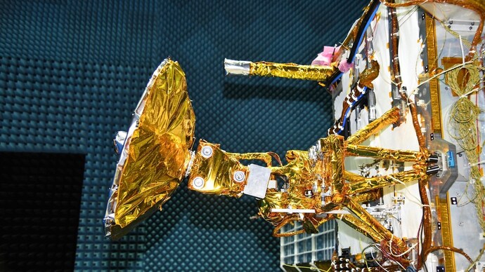
The Nisar satellite, a joint venture between Nasa and Isro, is now slated for liftoff from India aboard a GSLV Mark II rocket likely in March.

The NISAR observatory will be hoisted into orbit aboard Isro's Geosynchronous Satellite Launch Vehicle (GSLV). (Photo: Isro)
The Indian Space Research Organisation (Isro) is unlikely to launch Nisar, a joint mission with Nasa, in January.
According to sources close to the mission, the launch is likely to be pushed beyond February.
The much-anticipated Nasa-Isro Synthetic Aperture Radar (Nisar) mission is expected to be delayed beyond its initial timeline. The Nisar satellite, a joint venture between Nasa and Isro, is now slated for liftoff from India aboard a GSLV Mark II rocket likely in March from the Satish Dhawan Space Center in Sriharikota.
The Nisar mission is an international collaboration with both Nasa and Isro contributing advanced radar systems optimized to observe a wide range of changes on Earth's surface. This groundbreaking satellite will employ dual L-band and S-band frequencies to systematically map the planet, providing an unprecedented view of Earth's dynamic ecosystems, ice masses, and land surfaces.
With a mission life planned for three years, Nisar aims to revolutionise our understanding of environmental change and natural hazards. The satellite will map the entire globe every 12 days, offering spatially and temporally consistent data crucial for studying changes in ecosystems, vegetation biomass, sea level rise, groundwater, and the impact of natural disasters such as earthquakes, tsunamis, volcanoes, and landslides.
- We'd like two minutes of your time in order to understand you better. Please take this reader survey.
The satellite's advanced radar imaging technology is designed to capture high-resolution data, with a swath of approximately 240 km and resolutions ranging from 7 m along track to 2-8 m cross-track, depending on the mode.
This capability will enable Nisar to monitor Earth's changing frozen regions, observing nearly all land and ice surfaces twice every 12 days.
Nisar's comprehensive observation strategy will provide valuable insights into Earth's dynamic surface and interior, terrestrial ecosystems, water resources, and cold regions.
The mission's data will support a variety of applications, including the management of natural resources and hazards, enhancing our understanding of climate change, and contributing to the scientific community's knowledge of our planet's crust.
Published By:
Sibu Kumar Tripathi
Published On:
Jan 12, 2024


 English (US) ·